Markers indicate locations discussed in this article; click on a marker for more details about a location.
Read more about the neighborhoods mentioned in this article.
French Quarter
Bordered by the Mississippi River, Canal, Esplanade, and Rampart streets, the French Quarter is the original site of New Orleans. It is also known as the Vieux Carré, or the “Old Square.” More >
Gentilly
Bordered by Lake Pontchartrain, the Louisville and Nashville Railroads,Peoples Avenue and Bayou St. John, Gentilly is a culturally diverse, residential community. More >
Lower Ninth Ward
Border by St. Bernard Parish, the Florida Canal, the Industrial Canal, and the Mississippi River, the Lower Ninth Ward is one of the last districts to be developed in New Orleans. More >
Uptown/Downtown
In New Orleans Uptown and Downtown describe large sections of the city in respect to Canal Street and the Mississippi River, not individual neighborhoods. More >
“The Forgotten People of New Orleans”: Community, Vulnerability, and the Lower Ninth Ward
Juliette Landphair
Journal of American History, 94 (Dec. 2007), 837–45
Before Hurricane Katrina roared across New Orleans on August 29, 2005, few Americans had heard of the Lower Ninth Ward. After the hurricane caused major levee breaches through which waves of water rushed and tossed “homes and cars around like toys” in the area, the Lower Ninth Ward came to represent the convergence of destructive forces on a society: the hurricane; the geographical vulnerability of New Orleans; government neglect; and urban poverty and racial polarization.[1] In the half century before the storm, the Lower Ninth Ward had changed from a fairly integrated section of working-class neighborhoods to a predominantly African American community where family potlucks and poverty coexisted; yet the area’s reputation as remote and irrelevant persisted from its founding through the opening years of the twenty-first century. Residents rebuffed these stereotypes, insisting that portrayals of the Ninth Ward as isolated and dangerous failed to capture what it meant to the people who lived there: family, friends, and neighborhood. Indeed, soon after Hurricane Katrina forced them out, many residents were lobbying to return home. “It’s a great community,” one resident declared. “We want it back.”[2]
The narrative of two Ninth Wards emerging from rebuilding debates also distinguishes the area’s history. Over time, the seemingly disparate characterizations of vibrant community and isolated backwater actually reinforced each other as the struggle to define the Ninth Ward, particularly the Lower Ninth Ward, shaped how the area grew, flourished, and suffered. Amid municipal neglect and increasing impoverishment, Lower Ninth Ward residents developed cross-generational neighborhood bonds that encouraged activist pursuit of better public services and nourished cultural traditions singular to New Orleans. In the postindustrial Crescent City, the spread of crime and poverty particularly afflicted the Lower Ninth Ward, but while homicide rates were among the highest in the city, so were home ownership rates.[3] The Lower Ninth Ward story presents a complex challenge to residents and government officials alike: The area’s unsteady terrain and social marginalization encouraged the development of close-knit communities of people who helped create New Orleans, yet those very geological, economic, and social vulnerabilities present enormous obstacles to residents’ returning, despite their desire to do so.

Aerial view of the Industrial Canal Levee and Lower Ninth Ward, April 2006. Photo by Carol M. Highsmith. Courtesy Carol M. Highsmith.
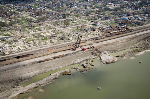
Aerial view of the Industrial Canal Levee and Lower Ninth Ward, April 2006. Floodwaters poured over the levee during Hurricane Katrina and remained trapped behind it in below-sea-level neighborhoods of the Lower Ninth Ward. Photo by Carol M. Highsmith. Courtesy Carol M. Highsmith.
In Hurricane Katrina’s aftermath, extensive flooding in the Lower Ninth Ward drew national attention to the area’s precarious geography. Yet the Lower Ninth Ward’s terrain is diverse and, as part of the city’s geological system, similar to that of other sections of New Orleans between the river and Lake Pontchartrain. One of several subdivisions of the large Ninth Ward voting district, the Lower Ninth Ward runs roughly one mile from its western Industrial Canal boundary to its eastern perimeter on the St. Bernard Parish border and one and one-half miles from the river to its northern periphery at Florida Avenue. The tract between the river and St. Claude Avenue is known as Holy Cross after a historic boys’ school. Across the Industrial Canal to the west sits the Upper Ninth Ward. Along the riverbank a natural levee rests ten feet above sea level and slopes downward into permeable terrain undulating at points four feet below sea level. The land then rises again as it advances north toward the Intracoastal Waterway levee.[4] This “dip” pattern—a below-sea-level depression between two swaths of higher ground—distinguishes many New Orleans neighborhoods and explains why floodwaters, trapped in such imperfect bowls, remained stagnant for weeks after Hurricane Katrina.
The levees, natural and man-made, in New Orleans
If New Orleans’s situation is remarkably good, its site may be equally bad. The city was built on sediment, the long ramp of the Mississippi’s levee. Follow thread in Kelman, “Clarifying New Orleans’s Murky Edges” >
Since the city is inexorably intertwined with the water surrounding it, geography has always dictated patterns of social settlement. In the 1800s wealthier residents built homes along the natural levee on former plantation land west (uptown) and directly east of the French Quarter, while less privileged settlers moved away from the high ground into flood-prone backswamps. The swampy expanse downriver that ultimately became the Ninth Ward attracted mostly free people of color and immigrant whites seeking to profit from the city’s commercial expansion but unable to afford property on higher ground.[5] In 1852, during a consolidation of the city and a reorganization of voting districts, the land was officially designated as the Ninth Ward. In the meantime, municipal officials seeking to modernize the city concentrated improvements in drainage and flood protection in wealthier areas of town that already benefited from the riverbank’s natural protection. Thus, from the Ninth Ward’s very start, vulnerable terrain combined with municipal neglect to secure its reputation as distant and uncivilized. “There are probably sections of the Ninth Ward,” one 1885 guidebook claimed, “which have never been visited by man.”[6]
In the late 1800s, the Ninth Ward’s isolation encouraged the growth of a self-sufficient communal culture among its residents. By 1890 over 17,000 people lived in the Ninth Ward. Settlers arrived in search of work, and the rural, neighborly environment often kept them there. With wood harvested from surrounding cypress trees, they built one-story shotgun houses, whose layout encouraged breezes to flow through the buildings as residents entertained neighbors on their front porches. Residents organized benevolent societies and mutual-aid associations and constructed churches. African Americans and whites alike recall considerable racial harmony in their early 1900s Ninth Ward upbringings. “Everybody helped everybody else,” one white man remembered decades later. “Every Saturday night, the blacks across the street would have a fish fry, and they would always bring a batch over to my mother. There was never any hatred between us; we all lived together and that’s the way things were.”[7]
Early migration to New Orleans
Throughout its early history, immigration drove population growth in New Orleans, and the city grew exceptionally fast. Follow thread in Fussell, “Population History” >
Settlement patterns began to change after the Louisiana Purchase. Follow thread in Campanella, “Ethnic Geography” >
Construction of the Industrial Canal during 1918–1923 disrupted the area’s bucolic feel. In the early 1900s, officials of the Port of New Orleans aspired to “coordinate river, rail and maritime facilities most economically” and to spur urban industrial growth by constructing a deepwater canal between the Mississippi River and Lake Pontchartrain. Looking downriver, the middle of the Ninth Ward appeared to offer the ideal site for the canal because, officials claimed, it was uninhabited.[8] In fact, by 1910, 25,599 people lived in the Ninth Ward, over 7 percent of the city’s population. Running five-and-one-half miles through the Ninth Ward, the massive canal reinforced the Lower Ninth Ward’s detachment from the rest of New Orleans. Still, the area continued to grow as employment opportunities drew newcomers to surrounding neighborhoods.[9]
As the century wore on, the Lower Ninth Ward’s literal and figurative isolation from central and uptown New Orleans bred a fierce loyalty among residents to their neighborhoods. It also encouraged civic activism focused on strengthening municipal services such as drainage and public education. In the 1940s and 1950s, for instance, the indigenous neighborhood advocacy of Lower Ninth Ward African Americans provided the impetus for New Orleans public school desegregation. Plaintiffs in two major legal suits supported by the National Association for the Advancement of Colored People (naacp) (Aubert v. Orleans Parish School Board, 1948, challenging the inequality of white and black New Orleans public schools, and Bush v. Orleans Parish School Board, 1952, challenging the constitutionality of segregated schools) hailed from the Lower Ninth Ward. Local naacp attorneys later recalled that few black New Orleanians dared to risk their families’ well-being and livelihoods in such a public way. Fueled by the hope of civil rights and better neighborhoods, however, some Lower Ninth Ward residents believed it was a risk worth taking.[10]
Public rights in nineteenth-century New Orleans
During the 1830s the Louisiana legislature ratcheted up the constraints on free people of color, pushing some of them to emigrate. Follow thread in Scott, “Road to Plessy v. Ferguson” >
The Ninth Ward provided not only the impetus but also the setting for public school desegregation. After a federal judge ordered desegregation in New Orleans to begin in 1960, a reluctant all-white Orleans Parish School Board chose five black girls from the Ninth Ward to desegregate two white elementary schools, one in the Lower Ninth Ward and one in the Upper Ninth Ward. The city remained silent about the chosen schools until four of the girls first appeared for class on November 14, 1960. Outraged Ninth Ward whites, primarily women, began to gather daily outside the schools to threaten and taunt the girls as they entered and exited the buildings. Fascinated by the spectacle of housewives screaming obscenities at first graders, scores of reporters arrived to broadcast the women’s fury to a national audience. Some observers concluded that class and race tensions caused the crisis. Indeed, Ninth Ward whites did resent privileged uptowners: “They send their children away, and then they support integration,” one grumbled. “Their children will go to college anyway, integration or not. It’s our schools that will be changed.”[11]
The protesters’ vitriol was a product of the neighborhoods around them. To whites the decision to initiate school desegregation in the Ninth Ward represented another example of the city’s disregard for their community. Ironically, it was the city’s chronic neglect that motivated Lower Ninth Ward African Americans to spearhead the grassroots effort for school desegregation. The 1960 school crisis revealed that while black and white residents shared a desire for a better Ninth Ward, they envisioned that improvement in vastly different ways.
Meanwhile, Ninth Ward whites continued the steady migration to St. Bernard Parish begun decades earlier. The movement contributed to a post–World War II local suburban explosion (aided by the draining of former backswamps and the construction of the interstate highway system) and reflected urban residential patterns nationwide. Supported by government incentives, whites across the United States moved by the millions into racially exclusive suburban developments. In the New Orleans metropolitan area from the 1930s through the 1980s, twice as many federally backed homeowner loans went to suburban residents as to Orleans Parish residents. African Americans, noting that retail services such as restaurants and corner groceries drained out of their neighborhoods alongside the departing whites, asserted that racism was the primary motivation for white flight. The historian Matthew D. Lassiter argued that this demographic shift in New Orleans and other U.S. cities resulted in the ascendance of a politically potent white suburban population whose color-blind, individualist rhetoric defending suburbanization masked post–Jim Crow “spatial apartheid” based on class and race. In the years before Hurricane Katrina, crossing the border from the black, poor-and-working-class Lower Ninth Ward to the primarily white, middle-and-working-class St. Bernard Parish bore out his argument.[12]
Suburban segregation
Historically a racially intermixed city, New Orleans became progressively more segregated. Between 1960 and the 1980s, many whites departed a second time, this time for the recently drained suburbs of Jefferson, St. Bernard, and eastern Orleans parishes. Follow thread in Campanella, “Ethnic Geography” >
A force peculiar to New Orleans, Hurricane Betsy, also exacerbated white flight from the Ninth Ward. In September 1965, that category 3 storm roiled out of the Gulf of Mexico and up the Mississippi River toward New Orleans. On the evening of Thursday September 9, 150 mph winds slammed into the city, driving a storm surge through the Intracoastal Waterway and the Industrial Canal into low-lying eastern areas of the city. Floodwater overtopped the levees and crashed through levee breaches to drown the Lower Ninth Ward and St. Bernard Parish beneath six to twelve feet of water; the rest of the city remained relatively unscathed. Images from Hurricane Betsy are virtually identical to ones from its 2005 successor: an ocean of rooftops; bloated, floating bodies; a barge resting incongruously on the Industrial Canal levee. Three days after the storm hit, police officers found “an elderly Negro woman” standing on a chair perched on her stove, neck-high in floodwater. Dozens drowned, hundreds of houses were destroyed, and thousands were left homeless.[13]
In the Lower Ninth Ward’s collective memory, Hurricane Betsy was the catalyst that drove remaining whites, already inflamed by school integration, to St. Bernard Parish. The storm also came to symbolize long-standing municipal indifference to the Ninth Ward. The hurricane’s devastation of the Lower Ninth Ward contrasted sharply with minimal damage to the rest of the city, and residents, accustomed to decades of neglect, were certain that officials purposefully blew up the Industrial Canal to spare the “richer upriver areas.”[14] Distant memories of another disaster informed that conviction: in 1927, acting at the behest of powerful New Orleans businessmen who feared that the engorged Mississippi River might break over the Crescent City, local officials ordered the public dynamiting of the Poydras levee south of New Orleans, destroying the homes and livelihood of thousands of residents of St. Bernard and Plaquemines parishes. While analyses of Hurricane Betsy uncover no evidence of intentional levee destruction, a 1965 New Orleans Sewerage and Water Board report did concede that much of the area’s drainage system could not handle above-average rainfall. In the aftermath of Hurricane Katrina, “Betsy” was recalled time and again by residents convinced that the 2005 storm damage and recovery effort somehow involved elite malfeasance.[15]
In the decades between Hurricanes Betsy and Katrina, New Orleans evolved into an African American city. As whites moved to the suburbs, the city’s population fell 22 percent, even as the number of African Americans rose. As the city grew blacker, it got poorer. Consumer services followed whites out of urban neighborhoods in search of suburban relocation. The port’s containerization wiped out well-paying jobs for thousands of blue-collar New Orleanians. Manufacturing jobs declined citywide.[16]
The race and class dynamics reshaping New Orleans were particularly salient in the Lower Ninth Ward. From 1940 to 1970, the nonwhite population of the area rose from 31 percent to 73 percent, and by 1970, 28 percent of Lower Ninth Ward families lived below the poverty line. By 2000, approximately 90 percent of the Lower Ninth Ward was African American, and 33 percent lived in poverty. A 2003 study of 258 Lower Ninth Ward homes found that 56 percent had “at least one hazard (e.g., excessive moisture or pest infestation).”[17] Crime and violence soared in the area, which became, in the words of the criminologist Peter Scarf, “the murder capital of the murder capital.” Vacated houses harbored drug users and dealers alike, and residents began complaining to officials that children no longer played outside and that fearful friends refused to stop by for casual visits. In local news “Ninth Ward” and “homicide” appeared together regularly; as one resident recalled, “we only made television or made the paper when someone was shot and killed or when there was enough water to show cars slowly driving through the floodwaters.” The Ninth Ward stereotype acquired sinister overtones: it was now a dangerous backwater pockmarked with blight where one’s life was always at risk. Here as in cities across the nation, the conflation of poverty with race affirmed African American “underclass” typecasts of violent, live-for-the-moment young men and unwed, live-off-the-dole welfare mothers.[18]
Poverty
One part of the city’s history is difficult to ignore: the persistence of poverty and racial inequality. The tragic conditions exposed by Katrina were long in the making, but for a period in the 1960s and 1970s, thousands of New Orleanians tried to shift the trajectory of deprivation and exclusion. Follow thread in Germany, “Racial Inequality and the Long Prelude to Katrina” >
In post-Katrina New Orleans, it is not too much to say that poverty is the new prostitution—a tiresome urban problem that most know is not going away, but would just as soon not have to look at or deal with directly.
Follow thread in Long, “Race, Poverty, and Public Housing” >Lower Ninth Ward residents took umbrage at those stereotypes. Presumptions of laziness particularly galled them. “Everyone seems to think the poor, lower income people that don’t do anything [live here],” one resident claimed. “But they’re hard-working people down here.” They proudly pointed out nearby houses owned by relatives to emphasize how family networks encouraged a homely, neighborhood feel. Waukesha Jackson recalled that “meeting the people on my grandma’s block was the best thing that ever happened to me because they’re just like family.” Other residents described the Lower Ninth Ward as a rung on the ladder of upward mobility: their relatives had moved there because real estate was affordable; between 1940 and 1960, many of them constructed new houses that remained in the family into the new century.[19] Lower Ninth Ward residents insisted that official indifference to their neighborhoods perpetuated crime and blight; rarely seen police officers, they charged, seemed more intent on hassling law-abiding citizens than on pursuing real criminals. Race saturated the vocabulary of neglect as African American residents insisted that white landlords bore responsibility for crime by failing to maintain their rental properties and to monitor who moved in and out.[20]
Lower Ninth Ward civic activism continued into the twenty-first century. Residents joined existing or newly formed organizations to lobby for playgrounds, public school facilities, health clinics, and protection against environmental hazards. Such local allegiance was not unique to the Lower Ninth Ward; areas such as Broadmoor, Mid-City, and New Orleans East also bred intense neighborhood loyalty among their residents. The Lower Ninth Ward did stand out, however, in its residents’ long-standing conviction that the area was “forgotten.” In one 2001 community forum, over one hundred citizens applauded when the Lower Ninth Ward resident Betty Stewart claimed, “Our fears are what bring us out tonight. The forgotten people of the Lower 9th refuse to be forgotten any longer.”[21]
In August 2005, a force outside human control threw the city into chaos: Hurricane Katrina. After hitting Florida on Thursday August 25 and subsiding to a tropical storm, Hurricane Katrina regrouped and headed toward the Mississippi/Louisiana coast. On Friday, Louisiana governor Kathleen Blanco declared a state of emergency; the following day, New Orleans mayor C. Ray Nagin followed suit. By Sunday, a direct Crescent City hit appeared probable, and Nagin announced the city’s first mandatory evacuation in history. Before the hurricane made landfall on Monday, 80 percent of metropolitan-area citizens had fled; the 20 percent remaining included elderly New Orleanians, New Orleanians without resources, and warning-weary New Orleanians who had lived through unfulfilled predictions of doom in the past.[22]
As with Hurricane Betsy forty years earlier, Hurricane Katrina arrived in the Lower Ninth Ward as an eruption of sound and water. And as during its predecessor, levee breaches caused both eruptions. Around 6:50 a.m., the eye of the hurricane proceeded northward over Lake Borgne east of the city. Hurricane winds pushed a sixteen- to nineteen-foot-high storm surge westward through the Intracoastal Waterway and into the Industrial Canal. Levees cracked and leaked from the pressure and water poured over their walls into St. Bernard Parish and the Lower Ninth Ward. Then, between 7:30 and 7:45 a.m., nine hundred feet of floodwall collapsed near Claiborne Avenue on the Industrial Canal’s east side. As an engineering report later described it, “the inrushing waters entered the adjacent community with great force. Homes for several blocks were ripped from their foundations and scattered, usually in splinters, eastward across the inboard neighborhood.”[23]
Hurricane Katrina, the most expensive storm in U.S. history, is only the most recent hurricane to affect the U.S. gulf coast. Since the turn of the twentieth century, several notable storms have hit the region, bringing death and destruction to countless coastal communities.
The deadliest hurricane in U.S. history made landfall on the afternoon of September 8, 1900. A category 4 storm, the Galveston Hurricane arrived with little warning and beat the city with over 100 mph sustained winds until late into the night, killing over 8000 residents, and leveling 12 city blocks.
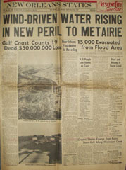
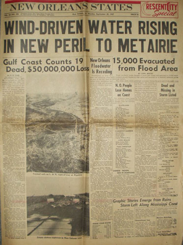
New Orleans States, September 22, 1947. "Wind-driven water risingin new peril to Metairie." Courtesy Hurricanecity.com
New Orleans States, September 22, 1947. "Wind-driven water risingin new peril to Metairie." Courtesy Hurricanecity.com
The 1947 Fort Lauderdale Hurricane devastated parts of Florida before reenergizing over the Gulf of Mexico and making a second landfall in New Orleans on the morning of September 19. A direct hit, the category 3 hurricane flooded Metairie and other areas near the 17th Street Canal.
In 1965 Hurricane Betsy became the first hurricane to cause damages in excess of $1 billion. “Billion-dollar Betsy” was a category 3 hurricane, and it slammed into New Orleans on September 9, driving a storm surge into Lake Pontchartrain and overwhelming the Industrial Canal levees. Flooding in the Lower Ninth Ward reached the eaves of several homes and over the roofs of others.
On August 19, 1969, Hurricane Camille ravaged the Mississippi coastline with record-setting intensity. The strongest storm to ever make landfall along the Gulf Coast, Camille’s 190 mph sustained winds and a 25-ft storm surge stripped the land of all man-made structures within a half mile of the ocean and caused flooding as far north as Virginia.
Hurricane Georges was the second major hurricane of the 1998 Atlantic hurricane season. It made seven landfalls in six different countries before coming ashore near Biloxi, Mississippi, on September 28. Despite being only a category 2 hurricane, the impact of Georges was felt throughout the gulf region. Parts of Mississippi, Louisiana, Georgia, Florida, and Alabama endured 8- to 10-foot storm surges, torrential rains, and multiple tornados; however, due to advance warning and well-executed evacuation plans, the death toll from Hurricane Georges is low.
The 2005 Atlantic hurricane season was one of the most active on record. It spawned Katrina and six other major hurricanes, of which three—Dennis, Wilma, and Rita—made landfall in the United States. The 2005 Atlantic hurricane season was responsible for over 2,000 deaths and damages of over $125 billion.
And thus, once again, floodwaters engulfed the Lower Ninth Ward and St. Bernard Parish. Local and national media reports were simultaneously announcing that New Orleans had yet again escaped a direct hit. Around the nation, evacuated New Orleanians, sitting on hotel beds and in living rooms, exhaled sighs of relief. But Jeanne Parker experienced firsthand the prematurity of those declarations. Parker had decided to ride out the storm in her one-story house on Charbonnet Street in the Lower Ninth Ward, “built from the ground up” by her father. Over the preceding days, her neighbors had trickled out, several succumbing hours before to evacuation entreaties from their pastors. As dawn approached, Parker’s daughter in Virginia called, begging her to get out. It was too late: Parker heard a deafening noise, and then water was in her home, one foot, then two, then to her chin. She employed her pre-storm “evacuation plan,” groping her way through the water and wind to the two-story home across the street, where she waited for rescue.[24]
The wave that cascaded down on the Lower Ninth Ward united with other floodwaters and eventually settled into a fetid stillness, covering the area like a thick blanket. Over the following days, in agonizing heat and humidity, rescuers evacuated residents such as Jeanne Parker to the Superdome and Convention Center. As the weeks passed and water drained away, rotting corpses, shattered houses, and muck-caked tricycles rested in the silence. City inspectors deemed the majority of Lower Ninth Ward properties “unsafe to enter or in imminent danger of collapse,” their condition a reflection of the floodwaters’ impact and the unsteady foundations of shotgun homes that had lined block after block. Preliminary reports indicated that the Lower Ninth Ward and Gentilly, the city’s most ravaged areas, experienced the highest number of deaths by drowning. After viewing the Lower Ninth Ward’s annihilation, Col. Terry Ebbert, the New Orleans head of the federal Department of Homeland Security, was not alone in concluding that “there’s nothing out there that can be saved at all.”[25]
Debates over rebuilding New Orleans began immediately. In reports and discussions about the Ninth Ward, familiar issues of race and class came to the fore. For every argument for razing the area, residents made counterarguments based on decades of experience. While experts warned against rebuilding the Lower Ninth Ward because of its low-lying, permeable terrain, residents insisted that the susceptibility to flooding was exaggerated, even bogus. As homeowners in wealthier yet equally vulnerable areas such as Lakeview began rebuilding in the muck, Lower Ninth Ward residents wondered why their beloved community sat still despite a shared desire to restore it. When Mayor Nagin announced a recovery plan that laid responsibility for reconstructing neighborhoods on residents, Lower Ninth Ward evacuees cried foul: more privileged and connected communities “are more able than others” to rebuild, one homeowner pointed out. Suspicions about elite intentions gathered steam: Was this an excuse to clean out this poor, overwhelmingly African American community so that rich white developers could start anew?[26]
The image of two Ninth Wards thus lingers in the debris. Ironically, the Lower Ninth Ward—historically neglected, stigmatized, and peripheral to the city’s power structure—is now a household name across the nation, symbolizing the storm’s human disaster. Its history suggests that rebuilding requires more than new houses: it calls for jobs, public transportation, and a pattern of retail services placing the area squarely within—not isolated from—the city’s economy. It demands cooperation between government officials and scientists to build the best flood protection system possible. Finally, and most important, resuscitation requires supporting thousands of displaced residents in their desire to return home. In the meantime, they must follow the lead of their famous neighbor, Fats Domino, who declared in March 2006, “I’m gonna wait it out. I don’t think I’ll ever leave the Ninth Ward.”[27]
[1] I drew the title of this article from a former resident who called the Ninth Ward “the forgotten people of New Orleans”: Rosana Aubert to Juliette Landphair, Jan. 15, 2000 (in Juliette Landphair’s possession). See the interactive graphics: Dan Swenson, “Flash Flood: Hurricane Katrina’s Inundation of New Orleans, August 29, 2005,” scene 8, New Orleans Times-Picayune, http://www.nola.com/katrina/graphics/flashflood.swf.
[2] Pam Dashiell interview, Talk of the Nation, Oct. 4, 2005, National Public Radio, http://www.npr.org/templates/story/story.php?storyId=4944960.
[3] Frank Etheridge, “Last of the Ninth,” New Orleans Gambit Weekly, Nov. 22, 2005, http://www.bestofneworleans.com/dispatch/2005-11-22/cover_story2.php. On home ownership, see the figures from the 2000 census in “Lower Ninth Ward District, Lower Ninth Ward Neighborhood: Housing and Housing Costs,” Greater New Orleans Community Data Center, http://www.gnocdc.org/orleans/8/22/housing.html.
[4] Richard Campanella, Geographies of New Orleans: Urban Fabrics before the Storm (Lafayette, 2006), 55.
[5]Ibid., 298–300; Peirce F. Lewis, New Orleans: The Making of an Urban Landscape (Santa Fe, 2003), 51–52.
[6] George E. Waring Jr., Report on the Social Statistics of Cities: The Southern and Western States (Washington, 1887), 272; Craig E. Colten, An Unnatural Metropolis: Wresting New Orleans from Nature (Baton Rouge, 2005), 77–107. The guidebook is quoted in Joy J. Jackson, New Orleans in the Gilded Age: Politics and Urban Progress, 1880–1896 (Baton Rouge, 1969), 8.
[7] U.S. Department of the Interior, Census Office, Report on Vital and Social Statistics in the United States at the Eleventh Census: 1890, pt. II: Vital Statistics (Washington, 1896), 372; E. J. Morris Senior Center, “Oral Recollections of the Ninth Ward Elderly, 1900–1950,” 1983, vertical file “Ninth Ward,” pp. 44–47, Louisiana Collection (Howard-Tilton Memorial Library, Tulane University, New Orleans, La.); “Readers Talk about Race Relations,” New Orleans Times-Picayune, Oct. 9, 1993, p. A16; Leontine Luke interview by Kim Lacy Rogers, May 22, 1979, audiotape, Kim Lacy Rogers–Glenda B. Stevens Collection (Amistad Research Center, Tulane University).
[8] Thomas Ewing Dabney, “The Industrial Canal and Inner Harbor of New Orleans. History, Description and Economic Aspects of Giant Facility Created to Encourage Industrial Expansion and Develop Commerce,” 1921, esp. pp. 6 and 16, Louisiana Collection; Lewis, New Orleans, 75.
[9] U.S. Department of Commerce, Bureau of the Census, Thirteenth Census of the United States Taken in the Year 1910, Reports by States, vol. II: Population 1910, Reports by States, with Statistics for Counties, Cities and Other Civil Divisions, Alabama–Montana (Washington, 1913), 793. Between 1920 and 1940, the Ninth Ward grew 64%. U.S. Department of Commerce, Bureau of the Census, Fourteenth Census of the United States Taken in the Year 1920, vol. III: Population 1920, Composition and Characteristics of the Population by States (Washington, 1922), 404; U.S. Department of Commerce, Bureau of the Census, Sixteenth Census of the United States: 1940, vol. II: Population, Part 3: Kansas–Michigan (Washington, 1943), 425.
[10] Daniel Byrd interview by Daniel Legendre, Oct. 27, 1978, transcript, p. 9, folder 9, box 8, Daniel Byrd Papers (Amistad Research Center). See also Juliette Landphair, “Sewerage, Sidewalks, and Schools: The New Orleans Ninth Ward and Public School Desegregation,” Louisiana History, 40 (Winter 1999), 35–62; Aubert v. Orleans Parish School Board, Civil Action no. 215 (E.D. La. 1948); Bush v. Orleans Parish School Board, Civil Action no. 3630 (E.D. La. 1960); Orleans Parish School Board v. Bush, 365 U.S. 569 (1961).
[11] For an example of national coverage of New Orleans desegregation, see Douglass Cater, “The Lessons of William Frantz and McDonogh 19,” Reporter, Feb. 16, 1961, pp. 36–39. Robert Coles, Children of Crisis: A Study of Courage and Fear (Boston, 1967), 124.
[12] On homeowner loans, see “Once-Diverse City Is Now Segregated,” New Orleans Times-Picayne, Nov. 17, 1993, p. A16. “Miles between Us: Flight from City Creates Division,” ibid., p. A1. Matthew D. Lassiter, The Silent Majority: Suburban Politics in the Sunbelt South (Princeton, 2006), 1–19.
[13] Sewerage and Water Board of New Orleans, “Report on Hurricane Betsy, September 9–10, 1965,” Oct. 8, 1965, p. 23 (Howard-Tilton Memorial Library); “State’s Death Toll Mounting,” New Orleans Times-Picayune, Sept. 13, 1965, p. 3.
[14] Monicker Field, Jeannette Trask, and Tanya Harris interview by Juliette Landphair, June 10, 2006, notes (in Landphair’s possession); Etheridge, “Last of the Ninth.”
[15] Ari Kelman, A River and Its City: The Nature of Landscape in New Orleans (Berkeley, 2003), 184; John M. Barry, Rising Tide: The Great Mississippi Flood of 1927 and How It Changed America (New York, 1997), 234–58, 275–81; Sewerage and Water Board, “Report on Hurricane Betsy,” 30.
[16] Lewis, New Orleans, 124–25; Campanella, Geographies of New Orleans, 293; Jonathan Maslow, “Blues in the Gulf: Seaports along the Gulf of Mexico Gambled on Expanding North-South Trade, and Lost,” Atlantic Monthly, 261 (May 1988), 1, available at Academic OneFile.
[17] J. Lambert Molyneaux and Anthony V. Margavio, “Population Change in New Orleans from 1940 to 1960,” Louisiana Studies, 9 (Winter 1970), 237; U.S. Department of Commerce, Bureau of the Census, 1970 Census of Population and Housing, New Orleans, LA (Washington, 1972), 65; “Lower Ninth Ward District,” Oct. 4, 2002, Greater New Orleans Community Data Center, http://www.gnocdc.org/orleans/8/index.html. On housing hazards, see Robert O. Zdenek et al., “Reclaiming New Orleans’ Working-Class Communities,” in There Is No Such Thing as a Natural Disaster: Race, Class, and Hurricane Katrina, ed. Chester Hartman and Gregory D. Squires (New York, 2006), 171.
[18] Peter Scarf is quoted in Etheridge, “Last of the Ninth.” “Resident of the Lower Ninth Ward Takes the Lead; He’s Helping to Make Area Safer, Cleaner,” New Orleans Times-Picayune, Dec. 23, 2004, p. 13, available at Lexis-Nexis; Will Sutton, “New Orleans’ Lower Nine Fades, Fades, Fades Away,” Neiman Reports, 59 (Winter 2005), 38. See, for instance, Michael B. Katz, “The ‘Urban Underclass’ as a Metaphor of Social Transformation,” in The “Underclass” Debate: Views from History, ed. Michael B. Katz (Princeton, 1993), 10–14.
[19] Field, Trask, and Harris interview; Waukesha Jackson, What Would the World Be without Women: Stories from the Ninth Ward (New Orleans, 2005), 15, 19; Jeanne Parker interview by Landphair, June 23, 2006, notes (in Landphair’s possession); Sutton, “New Orleans’ Lower Nine Fades, Fades, Away,” 37.
[20] “Miles between Us,” p. A1; “Ninth Ward Residents Make a Stand; They Want More Police Presence,” ibid., July 17, 2001, p. 1, available at Lexis-Nexis. For the accusations against landlords, see “Miles between Us.”
[21] “Community Effort Results in Plans for Playgrounds,” New Orleans Times-Picayune, Sept. 30, 1993, p. 4A1, available at Lexis-Nexis; “Ninth Ward Residents Make a Stand.”
[22] Douglas Brinkley, The Great Deluge: Hurricane Katrina, New Orleans, and the Mississippi Gulf Coast (New York, 2006), 108.
[23] R. B. Seed et al., “Investigation of the Performance of the New Orleans Flood Protection Systems in Hurricane Katrina on August 29, 2005,” July 31, 2006, pp. 6.6–6.7, http://www.ce.berkeley.edu/~new_orleans/report/CH_6.pdf.
[24] Parker interview.
[25] “Demolition of Thousands of Houses Is Set to Begin,” New York Times, Dec. 17, 2005, p. A19; “Grim Map Details Toll in Ninth Ward and Beyond,” Washington Post, Oct. 23, 2005, p. A14. Terry Ebbert is quoted in Etheridge, “Last of the Ninth.”
[26] Field, Trask, and Harris interview; “In Rebuilding as in the Disaster, Wealth and Class Help Define New Orleans,” New York Times, April 25, 2006, p. 25, available at Lexis-Nexis.
[27] Robert Siegel, “Fats Domino, ‘Alive and Kickin’’ after Katrina,” All Things Considered, March 13, 2006, National Public Radio, http://www.npr.org/templates/story/story.php?storyId=5259801.