Zoomify Map
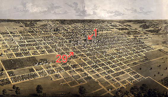
This 1867 bird's-eye map of Springfield has been enhanced with Zoomify, a free program available on the Web that allows viewers to magnify images such as historic maps. Viewers can use this zoomable map to view the Old State Capitol (#1 on the map key) and also the Lincoln residence on Eighth and Jackson streets (#29 on the map key). Zooming across this map allows a viewer to approximate something like the stroll Lincoln experienced when he walked from his home to the town square, where his law office was situated just across from the capitol building.
Powered by Zoomify
Map Key
- New Capitol
- Capitol
- Governors Residence
- State Arsenal
- Supreme Court & Post Office
- Court House
- High School
- Ward Schools
- Home of the Friendless
- Market House
- Illinois University
- Oak Ridge Cemetery
- Water Works
- Chicago & St. Louis R.R. Depot
- Toledo Wabash & Western R.R. Depot
- First Baptist Church
- Second Baptist Church
- Church of the Imaculate [Immaculate] Conception (Catholic)
- St. Peter & St. Paul Church
- Episcopal Church
- Lutheran Church
- German Lutheran Church
- First Methodist Church
- Second Methodist Church
- German Methodist Church
- First Presbyterian Church
- Second Presbyterian Church
- Third Presbyterian Church
- Universalist Church
- Lincoln’s Residence
- Lincoln’s Tomb
- Leland Hotel
- Chenery Hotel
- St. Nicolas Hotel
- Revere Hotel