Markers indicate locations discussed in this article; click on a marker for more details about a location.
Read more about the neighborhoods mentioned in this article.
Central Business District
Bordered by the Garden District, Mid-city, the French Quarter, and the Mississippi River, the Central Business District was call the "American Quarter" in the early 1900s. More >
French Quarter
Bordered by the Mississippi River, Canal, Esplanade, and Rampart streets, the French Quarter is the original site of New Orleans. It is also known as the Vieux Carré, or the “Old Square.” More >
Garden District
Bordered by St. Charles, Louisiana, and Jackson Avenues and Magazine Street, the Garden District is a residential neighborhood in the heart of New Orleans. It is known for its lavish gardens, elaborate architecture, and the famous St. Charles streetcar. More >
Gentilly
Bordered by Lake Pontchartrain, the Louisville and Nashville Railroads,Peoples Avenue and Bayou St. John, Gentilly is a culturally diverse, residential community. More >
Lower Ninth Ward
Border by St. Bernard Parish, the Florida Canal, the Industrial Canal, and the Mississippi River, the Lower Ninth Ward is one of the last districts to be developed in New Orleans. More >
St. Bernard Parish
St. Bernard Parish is a predominantly white residential area. Breaches in the Industrial Canal flooded the community during Katrina. More >
Uptown/Downtown
In New Orleans Uptown and Downtown describe large sections of the city in respect to Canal Street and the Mississippi River, not individual neighborhoods. More >
New Orleans Architecture: Building Renewal
Karen Kingsley
Journal of American History, 94 (Dec. 2007), 716–25
Architecture . . . is a subject that is fraught with genuine conflict, and it seems to have acquired an extraordinary capacity to make all kinds of people extremely angry about issues that range from the most intensely personal to the most diffusely political.
This essay on the architecture of New Orleans looks at certain features of the city—architectural icons, vernacular structures, and nature—and some conflicts they have provoked in the city’s renewal of its built fabric. I have structured the essay as a sequence of vignettes, a composition that reflects the fragmentary nature of the city as it reshapes itself in the aftermath of Hurricane Katrina.
Fifty years ago, Architectural Forum, a leading architectural journal of its day, featured a lengthy article titled “The new New Orleans.” The text begins: “New Orleans is midway in the greatest industrial transformation, change and civic growth in its history. . . . There would be nothing unique about all this in the booming southland, except that New Orleans is unique, possessing regional native flavor matched in few U.S. cities.” The author continues, “But brooding behind all this [industrial change] is the distinctive native architectural flavor of the city, and whether it will live or die.”[1]
Today, the change is not industrial—and in hindsight, the notion that New Orleans itself would experience industrial change is piquant. Nevertheless, now that the city suffers the effects of Hurricane Katrina, questions about architectural quality and change have resurfaced. As for the “native architectural flavor”—the author was referring to the city’s nineteenth-century buildings—how does that characterization apply to the city as a whole? After all, except in the Vieux Carré, Faubourg Marigny, the Garden District, and Uptown, which lie on the strip of higher land that borders the Mississippi River, and in a few other areas, such as Tremé, most of the city’s architectural fabric dates from the twentieth century. So although the city contains some of the oldest buildings in the nation, it is a modern city, a fact often lost on its inhabitants and certainly ignored by visitors seeking (or residents enamored of) a genuine historical ambience, who flock to the eighteenth- and nineteenth-century sections.
Jean Baptiste Le Moyne, sieur de Bienville, selected the site for New Orleans in 1718 for its relatively high elevation and the easy access to it from the Gulf of Mexico via Lake Pontchartrain. The city was laid out in 1721 on a typical French grid plan by the engineer Louis-Pierre Le Blond de la Tour and his assistant Adrien de Pauger. The centerpiece of their scheme was St. Louis Cathedral, fronted by a large square. Facing the Mississippi River, the building and square served as a gateway or reception hall to the city. In the early nineteenth century, the square was further monumentalized by the construction of the handsome Cabildo and Presbytère buildings that flank the cathedral. The Pontalba apartments constructed along two sides of the square in the mid-nineteenth century and the landscaping of the square, previously used as a parade ground, into a parklike space completed the transformation of this ensemble. A marvelous urban space was created. Views of the cathedral seen from across the square have been the most popular image of the city. Printed on postcards and in advertising, depicted in paintings and photographs, the cathedral achieved an iconic status.[2]
The city’s early growth beyond the Vieux Carré paralleled the natural levee formed by the Mississippi River’s deposits. New residential areas hugging this higher ground were laid out on former plantation lands both upriver and downriver from the Vieux Carré. And the city expanded for several blocks immediately on the landside of the Vieux Carré, forming the neighborhood of Tremé. Downriver (in present-day Marigny and Bywater) mostly small-scale Creole cottages and shotgun houses lined the streets. The surrounding cypress forests and, later, the pine forests north of Lake Pontchartrain provided building materials for the new city.
Levees and New Orleans
The city was built on sediment, the long ramp of the Mississippi’s levee. The highest ground is found along the river frontage. Follow thread in Kelman, “Clarifying New Orleans’s Murky Edges” >
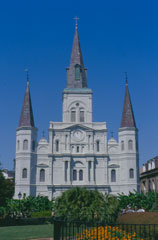
St. Louis Cathedral (built in 1849–1851) and Jackson Square, photographed from the Mississippi River levee in 2001. Photo by Karen Kingsley. Courtesy Karen Kingsley.
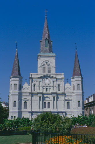
St. Louis Cathedral (built in 1849–1851) and Jackson Square, photographed from the Mississippi River levee in 2001. Such views of the cathedral across the square have provided the most popular image of the city. Photo by Karen Kingsley. Courtesy Karen Kingsley.
Following the Louisiana Purchase of 1803, Anglo-Americans flocked to New Orleans, seeking all the opportunities the bustling port city offered. Architects from New York came too, putting their stamp on the city in the form of brick town houses and the latest fashions in architectural styles and decoration, most notably the Greek revival. Sufficient numbers of those houses remain along Julia and Camp streets in the former Faubourg St. Mary (now the Central Business District) to give an idea of what the neighborhood looked like before it became so commercial.
Early immigration to New Orleans
Throughout its early history, immigration drove population growth in New Orleans, and the city grew exceptionally fast. Follow thread in Fussell, “Population History” >
Beginning in the mid-nineteenth century, the brick town houses gave way to warehouses and dock-related structures to serve the busy port and, in the last decades of that century, to tall commercial buildings. Wooden piles were driven deep into the city’s soft and unstable soils to support those tall buildings. The same technique, but with concrete piles, was used for the skyscrapers of the late twentieth century. Five hundred concrete octagonal piles driven 210 feet into the ground carry the fifty-one-story-tall Shell building of 1972 by Skidmore, Owings and Merrill.[3]
House/Home/Memory
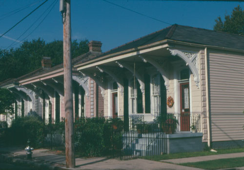
In the residential neighborhoods, the wooden Creole cottages and shotgun houses of the nineteenth century were raised on brick piers a few feet above the ground to protect their interiors from floods and heavy rainfalls. Those house types, especially the shotgun houses, continued to be built in the early twentieth century, for their design and plans allowed for cross-breezes, welcome in the city’s steamy climate. And with the advent of affordable machine-cut wooden decorative details, easily purchased from mill yards and from mail-order catalogs, house owners could compete with each other in the quantity and quality of such exterior embellishments as brackets, porch posts, scrolls, and edging, offering diversity amid the uniformity. Yet it is the overall uniformity that gives these neighborhoods their visual cohesiveness.
The last decades of the nineteenth century and the twentieth century imposed their uniformity or unity, from neighborhood to neighborhood—from the two-story, mostly wooden, grand mansions of Uptown with their bay windows and expansive galleries to the smaller houses downriver in Holy Cross and the Ninth Ward. As the city spread toward Lake Pontchartrain, after the Sewerage and Water Board of New Orleans’s powerful new steam pumps drained the below-sea-level areas between older neighborhoods and the lake, beginning in the early twentieth century, a similar uniformity was established. Gentilly Terrace was developed with California-style stucco-covered, red-pantile-roofed bungalows. New subdivisions closer to the lake were filled with the mix of architectural styles that dominated the mid-twentieth century, including the low-ceilinged and ranch-style houses that proliferated after the advent of air conditioning. Most of these houses were built on concrete slabs, as were those in the residential subdivisions that began to creep eastward across the Industrial Canal in the 1960s and 1970s.[4]
Expansion beyond the natural levee
Between 1893 and 1915, New Orleans installed a world-class urban drainage system. The Progressive Era municipal-improvement project effectively neutralized topography as the premier factor restricting urban expansion.... New Orleans began to expand off the natural levee of the Mississippi and into the lowlands near Lake Pontchartrain. Follow thread in Campanella, “Ethnic Geography” >
Thus, the city’s growth patterns could be traced in the differing mix of types and styles of residential architecture from neighborhood to neighborhood—the divisions were so clear. And while the new was built, very little of the old was replaced. But it is the old—the nineteenth-century city that hugs the river, the city that tourists see and that did not get flooded—that is the New Orleans of the imagination. Those areas give the illusion of an ancient timelessness even as the city has undergone an enormous expansion and transformation in the past century. So although New Orleans is a twentieth-century city, it is still perceived as a nineteenth-century city and a sort of architectural museum of romance and picturesque decay. The past is fetishized. Some notions are too dear to abandon (for New Orleanians or for the visitors?), perhaps too necessary.
If engineers, architects, and planners give cities their form, they do not control the meaning of their creations. Buildings and places derive their meaning from the way they are used, the events that grow up around them, the myths and stories that are created over time. Buildings and their neighborhoods were the setting where New Orleanians defined their identity, developed their customs and rituals, and understood their sense of place. After Katrina disrupted those histories and memories, people looked to their buildings and neighborhoods even more desperately.
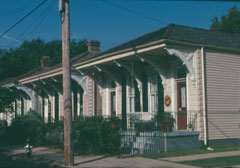
Shotgun houses, built c. 1890 on Camp Street in New Orleans’s Garden District and photographed in 1998. Photo by Karen Kingsley. Courtesy Karen Kingsley.
St. Louis Cathedral (built in 1849–1851) and Jackson Square, photographed from the Mississippi River levee in 2001. Such views of the cathedral across the square have provided the most popular image of the city. Photo by Karen Kingsley. Courtesy Karen Kingsley.
In an article in the New Yorker, Dan Baum reported that “in general, when New Orleanians describe what they love about the city, the first thing they mention is neither the food nor the music but the intimacy of the neighborhoods—knowing everybody on the block where you were born, and never leaving.” Similarly, writing in Architectural Record, the architect James S. Russell noted “the fierce desire of residents to return to exactly their own street and their own house.” Nghana Lewis of the English Department and African and African Diaspora Studies program at Tulane University observed that, generally speaking, among people with limited means, family members “either are living in the same household or they are living in units that are close together or homes that are close together and that is their world. That is community. Family is community.” The city’s dense architectural character—even the large houses in the uptown neighborhoods are closely spaced—generated a sense of community. In the city’s older sections, the neighborly tradition of sitting on front porches lingered despite the advent of air conditioning, as did a vibrant street life of sidewalk parties and neighborhood parades that bound each community.[5]
New Orleans Green
The people who made New Orleans their home marked their neighborhoods by building churches. One would expect the city to have a skyline of spires, towers, and domes. Instead, against a backdrop of mountainlike clouds, much of the city’s skyline is marked by a tangle of telephone and electrical poles with their wires seemingly intertwined with the branches and leaves of the live oak, magnolia, cypress, and crape myrtle trees that line the streets. This arboreal greenness and lushness is another defining feature of the city. Unlike most American cities, New Orleans is green year round. Shade from the trees reduces the temperature by ten degrees or so, making it possible to walk in the daytime during the endless and steamy summers.
Building churches, building communities
When Hurricane Katrina made landfall in August 2005, African American churches in New Orleans were both heirs of and contributors to the community-building tradition of the black church. Follow thread in DeVore, “Rebuilding New Orleans Black Churches” >
The many shades of green have always given a special character to the city. But, ochers, browns, and sepias became the city’s colors in the months after Katrina. The standing salty water and weeks of posthurricane drought created a gaunt landscape of defoliated trees, many stripped of their branches, or dead altogether. The landscape historian Lake Douglas wrote shortly after the hurricane, “our open spaces, trees, and vegetation—vital parts of our community’s identity—will look ravaged for a long time.” And he added, “Gone too, at least for a while, are the intricate shadow patterns that we’re all used to seeing on the ground plane.”[6] Light, shadow patterns, textures that dissolved solidity could give the sense of being in a bower, or perhaps a cage. Streets, neighborhoods became wrapped into themselves, perhaps reinforcing New Orleanians’ embrace of the past and resistance to change.
Superdome (as Symbol)
Where trees and telephone wires trace the horizon of the residential neighborhoods, in the Central Business District, the Superdome fills that role and is the marker of place. As an urban icon, the Superdome has power by size alone. At street level, the structure’s dome offers a seductive curve to counteract the crisp edges of the high-rise buildings along Poydras Street. Viewed from the elevated interstate freeway that partially surrounds it, the Superdome appears as a vast mound, conveying permanence.
New Orleans’s Central Business District (cbd) has been bustling with commerce since the early 1800s. Located in the heart of the city, the cbd is bounded by Claiborne Avenue, the Pontchartrain Expressway, Canal Street, and the Mississippi River. Nestled between the French Quarter and the Garden District, the district is equivalent to “downtown” in other cities and is home to the Superdome and countless hotels, restaurants, and art galleries.
Like most of the city, the cbd was originally a French plantation. The plantation passed through many owners until 1788 when its owner, Bertrand Gravier, surveyed and divided the land creating a new neighborhood called Faubourg Sainte-Marie. Sparely populated for many years, Faubourg Sainte-Marie, known today as Faubourg St. Mary, benefited from the influx of Americans to New Orleans following the 1803 Louisiana Purchase. The area’s population soared. The new residents of the “American Quarter” built American-style townhouses and the city’s first Protestant churches.
Business arrived in the district in 1824 with the construction of New Orleans’s first gas-lighted building, the American Theater. As the popularity of gas grew, a gas works was erected in Faubourg St. Mary, along with other gas-lighted commercial buildings, including landmarks such as the luxurious St. Charles Hotel. The construction of the New Basin Canal in 1832 cemented the area’s reputation as the city’s central business district and brought unprecedented prosperity to the area until the Civil War.
During the Civil War, construction in Faubourg St. Mary stopped, and the area experienced significant declines; however, in 1868 Louisiana was readmitted to the Union and activity returned to the cbd. The city’s deep-water port opened in 1870. The next decade saw the introduction of skyscrapers, electric lighting, and the city’s first streetcar. Subterranean sewage system and asphalt-paved streets greeted the twentieth century. From 1870 to stock market crash of 1929, the cbd thrived.
The cbd’s economic decline lasted into the early 1980s, when tourism began to increase in New Orleans. The Superdome opened in 1975, and the district hosted the 1984 World Exposition. The World Exposition, though a financial failure, spurred the renovation of many of the area’s older buildings and warehouses to usable commercial spaces. Today, the district is home to such notable businesses as Emeril’s, Harrah’s casino, and the historic Whitney Hotel.
The cbd suffered some flooding during Hurricane Katrina, but most of the damage was attributed to wind. Many of the businesses in the cbd started reopening by the end of 2005.
Built as a venue for conventions, sports events, and other large-scale attractions, the Superdome was another component in the renewal of downtown New Orleans and the civic area that had begun in the 1950s with the building of a new city hall. The decision to locate the Superdome in the heart of New Orleans rather than in the suburbs was controversial, but it gave the city a new economic base. Moreover, as the urban historian Peirce F. Lewis observed in 1976, a year after it opened, “the Superdome is more than just a very large building. It is a fundamental change in New Orleans psychology from the old days when the city was run by a handful of old-timers. . . . The old, closed, conservative city was open for business.”[7]
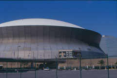
The Louisiana Superdome (built in 1971–1975, shown here in a 2006 photograph) was designed to withstand hurricane-force winds and to revitalize downtown New Orleans. Photo by Karen Kingsley. Courtesy Karen Kingsley.

St. Louis Cathedral (built in 1849–1851) and Jackson Square, photographed from the Mississippi River levee in 2001. Such views of the cathedral across the square have provided the most popular image of the city. Photo by Karen Kingsley. Courtesy Karen Kingsley.
Designed in 1967 by a consortium of architects with Curtis and Davis, Architects, as the lead architectural design firm and constructed between 1971 and 1975, the concrete structure covers thirteen acres on a fifty-two-acre site. The dome itself has a diameter of 680 feet, which made it, when built, the world’s largest clear-span structure. The interior rises 273 feet from floor to summit and the dome is formed from twelve steel ribs and a mesh of steel that holds a tension ring at the crown; this gives flexibility of movement to allow expansion and contraction as the temperature changes. The dome’s exterior is a thick layer of polyurethane and a waterproof covering. The Superdome was designed to withstand hurricane-force winds of up to 200 mph.[8]
When completed, the Superdome was lauded in magazines and scholarly journals alike, with such descriptions as “A People Place” (true indeed, but the writer meant as a venue of pleasure, not disaster).[9] The articles, however, glossed over the squabbles about the appropriation of land for the site and cost overruns, squabbles that surrounded the project and continued long after it was completed.
If the most compelling architectural images on our television screens in the aftermath of Katrina showed the city’s neighborhoods and destroyed houses, the most compelling image of a single building was that of the Superdome. Views of it were broadcast worldwide: from its exterior with the long lines of people seeking shelter before Katrina to scenes of the interior in the days following and, subsequently, to the building’s exterior with crowds of people waiting evacuation by bus. The Superdome stood as the emblem of all that went wrong. And on the one-year anniversary of Katrina, it became the most used image in the news media, featured, for example, on the front page of the New York Times and forming the backdrop to the evening news programs on television.[10]
As the shelter of last resort, the Superdome served its purpose, however awful the conditions inside it. The popular symbol that had communicated pride in the city’s progress now became a symbol of civic failure. It became that because of the human drama played out in it, yet that drama would not have happened without the Superdome’s architecture. The human drama has added to the building’s meaning. The Superdome now stands as the architectural emblem of the city, replacing the perennial favorite, St. Louis Cathedral and Jackson Square. Here there may be a curious inversion: where the historic cathedral has represented twentieth-century New Orleans, the late twentieth-century Superdome could become the city’s symbol as New Orleans shrinks closer to its late nineteenth-century size.
In the months following Katrina, when the post office was temporarily housed in trailers near the Superdome, the building became a familiar friend. One could see the men in white hazmat suits (to protect those handling hazardous materials) carting away tons of trash from the interior and, while waiting in line to purchase stamps, one could watch the roofers, who appeared ant size as they crawled over the dome’s exterior to repair it. Then the Superdome became a symbol of renewal. Hope for renewal animated the thousands of people in the Superdome when it opened for the season’s first National Football League game in September 2006, a mood decidedly enhanced by the triumph of the New Orleans team over its opponent. As a symbol, ideally, the Superdome should possess a dual personality—as a monument to the memory of Katrina and a locus of renewal, of efforts to create a more modern New Orleans, as it was when first built.[11]
The Newer New Orleans
A new New Orleans was at the center of various architectural and urban proposals in the year following Katrina. Among them were the Urban Land Institute’s proposal of November 2005 and recommendations issued by the Urban Design Subcommittee of Mayor C. Ray Nagin’s Bring New Orleans Back Commission in January 2006, which included more parks and a light-rail transport system. The city council set up a building committee and hired a new urbanist architectural firm to devise a land-use plan. Nothing came of those schemes, but each managed to enrage a lot of people, especially those whose homes and neighborhoods were ignored or described as expendable. In April 2006 the Rockefeller Foundation funded a new initiative to coordinate various grassroots efforts with those earlier schemes to prepare the Unified New Orleans plan, which was completed in January 2007 and forms a basis for ongoing discussion and evolution.[12]
Even before Katrina, the mayor had appointed a committee to consider the design of a new civic center and city hall to replace the current buildings. Since Katrina, that proposal has resurfaced as has a project to redevelop the former Hyatt Regency Hotel site, near the civic center, as the center of a twenty-acre jazz park.[13] Both schemes recognize the symbolic value of this civic corridor to showcase the city’s progressive face, echoing the area’s redevelopment of the 1950s, the focus of the 1957 article “The new New Orleans.” Although the present civic center buildings are undistinguished, as is the Hyatt, architecturally they reflect their time. Will the new designs, should they be built, be as bold in conception and design? Or, will the allure of the nineteenth-century past impact the design of the new buildings?
In fall 2006 a new controversy about old and new arose. It centered on the decision by the Catholic Church to relocate the destroyed Holy Cross School from the Lower Ninth Ward to the seventeen-acre site of St. Frances Cabrini Church in the Gentilly neighborhood. Completed in 1964, the church is uncompromisingly modern in design, and its open plan responded to the reform of the liturgy in the early 1960s in response to Vatican Council II. The design for Holy Cross replicates the destroyed school’s early nineteenth-century appearance. The school’s governing board maintained that the church needed to be demolished to provide space for the school and that its design would clash with the architecture of the school. While a small group protested demolition, the city’s largest preservation organization, the Preservation Resource Center [link], claimed the church was “probably not historic.” The Federal Emergency Management Agency (fema) stepped in, requesting a study. Editorials and letters from outraged citizens for or against demolition dominated newspaper editorial pages. One school board member denied any connection between the church’s design and Vatican II, which was refuted the next day by the architect, who knew better. The rhetoric heated up when a city council member claimed that if the church were allowed to stand, fema would be victimizing New Orleanians. She added that it was not an issue of architecture. But architecture is at the core of the issue. The church’s modern design is considered of little value because it does not look old or reflect received notions of the city’s architectural character. (In fact, the church could provide auditorium and chapel spaces that the school desires.) The contrast of the new rising up from the old is usually seen as a sign of progress. In this case, the new is facing an onslaught from the old.[14]
An exhibition of architectural projects using the title “A Newer New Orleans” was held in the Building Museum in Washington, D.C., in July 2006 [link]. Organized by the Tulane School of Architecture, the Netherlands Architecture Institute, and Artforum International magazine, the exhibition featured six proposals by American and Dutch firms. The opening section of the exhibition (the hors d’oeuvre) was a set of vividly colored maps (always a crowd pleaser) showing the topography of the city, the river sliding through the landmass, and the levels of inundation. The gorgeously colored designs were just as visually compelling. While most were oblivious to the city’s semitropical climate—they featured lots of large glass windows without overhangs to shade interior spaces and vast open outdoor spaces where pedestrians could bake in the heat or get soaked in the rain—the schemes were, as one of the organizers, Reed Kroloff, who was then dean of Tulane’s architecture school, said, “bright visions.” As he has so correctly asserted, “Some would have us believe our only future lies in that [eighteenth- and nineteenth-century architectural] past.”[15] Indeed, such passion for the past and an acceptance, or even glorification, of decay have fueled the myth and mystique of New Orleans and made it so easy for architects to fall back on historical forms in their designs, often in response to client request or public opinion. Nostalgia for the past is a powerful factor. Architecturally, it is the easy route, turning to the past to create the present.
One could level such architectural criticism at the traditionally designed shotgun houses that Habitat for Humanity is constructing in the Upper Ninth Ward for musicians. The simplicity of the designs is almost modern, and certainly the vibrant colors they are painted is in their favor. In contrast, the house and apartment designs by architects and architecture students submitted in response to two competitions organized by Architectural Record magazine and the Tulane School of Architecture are decidedly contemporary in style. The students’ house designs are the most exciting and viable, translating such New Orleans prototypes as the shotgun house into modern forms and employing a blend of modern and traditional materials. Similarly, the shotgun house constructed in the Tremé neighborhood by students in the URBANbuild program [link] of the Tulane School of Architecture and funded by the Department of Housing and Urban Development is a twenty-first-century version of the familiar type. Inserted into historic neighborhoods, these houses fit well; they are respectful of tradition while acknowledging their own era. And they create a new kind of timeline for New Orleans, not one that is read from neighborhood to neighborhood as the city grew, but one that is understood at a more intimate level within a neighborhood. It can be a timeline that better reflects the city’s human diversity.[16]
New Orleans is once again a city in process. To re-create it will, to borrow words, “mean a greater test of its imaginative spirits than New Orleans has ever faced.”[17] The new New Orleans depends not only on acknowledging the city’s many social ills and making a commitment to change them but also on not slipping back into a wistful yearning for some idealized period of the past.
[1] Robert Cantwell, “The new New Orleans,” Architectural Forum, 107 (Dec. 1957), 97–98.
[2] On the early architectural history of New Orleans, see Karen Kingsley, Buildings of Louisiana (New York, 2003).
[3]Ibid., 104.
[4]Ibid., 74–76, 111–12, 122, 136, 138–39, 141–42, 145–46.
[5] Dan Baum, “Letter from New Orleans: The Lost Year,” New Yorker, Aug. 21, 2006, p. 52; James S. Russell, “Can New Orleans and the Gulf Coast Face the Hard Questions?,” Architectural Record, 6 (June 2006), 132; Nghana Lewis quoted in Nick Marinello, “The Diaspora,” Tulanian, 78 (Summer 2006), 39.
[6] Lake Douglas, “A Preliminary Estimate of Katrina’s Toll on Public Open Spaces,” Landscape Architecture, 96 (Jan. 2006), 59, 60.
[7] Peirce F. Lewis, New Orleans: The Making of an Urban Landscape (Cambridge, Mass., 1976), 95.
[8] For drawings of, photographs of, specifications for, and correspondence about the Superdome, see “Superdome” subsection, Curtis and Davis Collection (Southeastern Architectural Archive, Tulane University Library, New Orleans, La.).
[9] “A People Place,” Compressed Air Magazine, 78 (Oct. 1973), 8.
[10] For example, the Superdome appeared in Washington Post, Aug. 31, 2005, pp. A1, A13; ibid., Sept. 1, 2005, pp. A1, A17; and ibid., Sept. 2, 2005, pp. A20, A23. A New York Times article featured before-and-after photographs: the first shot on September 3, 2005, the second on August 23, 2006. See New York Times, Aug. 23, 2006, p. A1. For the building’s appearance on tv, see http://www.nbc.com/ and http://www.cbs.com/.
[11] The $185 million spent to repair the Superdome (rather than to build or repair housing) was widely reported in news media and elicited an angry reaction from some New Orleans residents and evacuees, as well as people elsewhere. On the controversy, see Chris Rose, “Eternal Dome Nation,” New Orleans Times-Picayune, Oct. 3, 2006, p. B1.
[12] The proposals and counterproposals for rebuilding can be followed in the New Orleans Times-Picayune.
[13] Greg Thomas, “Grand Plan in Works for Plaza Dome,” New Orleans Times-Picayune, May 30, 2006, pp. A1, A8; Rebecca Mowbray, “Can Post-Katrina New Orleans Afford a New City Hall and Jazz Park Complex?” ibid., June 4, 2006, pp. A1, A7, A10; Michelle Krupa, “Windy City Wonder,” ibid., July 30, 2006, pp. A1, A8–13.
[14] Mark Schleifstein, “Church Designated as Historic by fema,” New Orleans Times-Picayune, Nov. 21, 2006, pp. A1, A4, esp. A4. For letters, see ibid., Nov. 21, 2006, p. B7; ibid., Nov. 22, 2006, p. B6; and ibid., Nov. 24, 2006, p. B6. For the architect’s comments, see Schleifstein, “Church Designated as Historic by fema,” p. A1; and Susan Finch, “Architect Says Church Should Be Preserved,” New Orleans Times-Picayune, Nov. 22, 2006, pp. A1, A3. On the council member’s remarks, see ibid., p. A2; and Schleifstein, “Church Designated as Historic by fema,” p. A1. St. Frances Cabrini Church was demolished June 5, 2007. See Daniel Monteverde, “Gentilly Church Demolition Proves Bittersweet for Many,” New Orleans Times-Picayune, June 6, 2007, pp. B1–2.
[15] Reed Kroloff and Aaron Betsky, “A Newer New Orleans: Six Proposals,” Artforum International, 44 (March 2006), 266–83, esp. 267.
[16] Doug MacCash, “Trumpeting Their Success,” New Orleans Times-Picayune, “Inside Out” section, Aug. 26, 2006, pp. 20–22; James S. Russell, “Building a Better Gulf South,” Architectural Record, 194 (June 2006), 112–29; Stephanie Bruno, “Shotgun for the Twenty-first Century,” New Orleans Times-Picayune, “Inside Out” section, Aug. 12, 2006, pp. 1, 20–23; Leslie Williams, “New from Old,” ibid., Oct. 17, 2006, pp. B1, B3.
[17] Cantwell, “new New Orleans,” 190.